

Typhoon #EgayPH (DOKSURI)
Issued at 5:00 AM, 25 July 2023
Valid for broadcast until the next bulletin at 8:00 AM today.
EGAY FURTHER INTENSIFIES AND IS NEARING SUPER TYPHOON CATEGORY.
•Location of Center (4:00 AM)
The center of the eye of Typhoon EGAY was estimated based on all available data including those from Daet Doppler Weather Radar at 350 km East of Tuguegarao City, Cagayan (17.2°N, 125.0°E)
•Intensity
Maximum sustained winds of 175 km/h near the center, gustiness of up to 215 km/h, and central pressure of 935 hPa
•Present Movement
West Northwestward at 15 km/h
•Extent of Tropical Cyclone Winds
Strong to typhoon-force winds extend outwards up to 680 km from the center
TROPICAL CYCLONE WIND SIGNALS (TCWS) IN EFFECT
TCWS No. 3
> Wind threat: Storm-force winds
> Warning lead time: 18 hours
> Range of wind speeds: 89 to 117 km/h (Beaufort 10 to 11)
> Potential impacts of winds: Moderate to significant threat to life and property
LUZON:
Babuyan Islands, the northern and eastern portions of mainland Cagayan (Santa Ana, Gonzaga, Peñablanca, Gattaran, Lal-Lo, Alcala, Santa Teresita, Buguey, Aparri, Camalaniugan, Ballesteros, Allacapan, Abulug, Claveria, Pamplona, Sanchez-Mira, Santa Praxedes, Lasam, Baggao, Amulung, Iguig), the northeastern portion of Isabela (Divilacan, Maconacon, Palanan), and the northern portion of Apayao (Calanasan, Luna, Santa Marcela, Flora, Pudtol)
TCWS No. 2
> Wind threat: Gale-force winds
> Warning lead time: 24 hours
> Range of wind speeds: 62 to 88 km/h (Beaufort 8 to 9)
> Potential impacts of winds: Minor to moderate threat to life and property
LUZON:
Batanes, the rest of mainland Cagayan, the rest of Isabela, Quirino, the northern portion of Nueva Vizcaya (Kasibu, Quezon, Diadi, Bagabag, Ambaguio, Villaverde, Solano, Bayombong), the rest of Apayao, Kalinga, Abra, Mountain Province, Ifugao, the northern portion of Benguet (Bakun, Mankayan, Buguias, Kabayan, Kibungan), Ilocos Norte, Ilocos Sur, and the northern and central portion of Aurora (Dilasag, Casiguran, Dinalungan, Dipaculao)
TCWS No. 1
> Wind threat: Strong winds
> Warning lead time: 36 hours
> Range of wind speeds: 39 to 61 km/h (Beaufort 6 to 7)
> Potential impacts of winds: Minimal to minor threat to life and property
LUZON:
La Union, Pangasinan, the rest of Benguet, the rest of Nueva Vizcaya, the rest of Aurora, Zambales, Bataan, Nueva Ecija, Tarlac, Pampanga, Bulacan, Metro Manila, Rizal, Laguna, Cavite, Batangas, Quezon, Marinduque, Camarines Norte, Camarines Sur, Catanduanes, Albay, Sorsogon, and the northern portion of Masbate (Uson, Dimasalang, City of Masbate, Mobo, Palanas, Aroroy, Baleno) including Burias and Ticao Islands
VISAYAS:
Northern Samar, the northern portion of Samar (San Jose de Buan, Matuguinao, Gandara, Santa Margarita, Calbayog City), and the northern portion of Eastern Samar (Oras, Arteche, Jipapad, Dolores, San Policarpo, Maslog)
HAZARDS AFFECTING LAND AREAS
Heavy Rainfall Outlook
Forecast accumulated rainfall today
• Above 200 mm: The eastern portion of Babuyan Islands and the northern portions of mainland Cagayan, Apayao, and Ilocos Norte
• 100-200 mm: Ilocos Sur, Abra, the northern portion of La Union, the western portion of Kalinga, and the rest of Babuyan Islands, mainland Cagayan, and Apayao.
• 50-100 mm: Batanes, the northern and eastern portions of Isabela, the northern portion of Zambales, and the rest of Ilocos Region and Cordillera Administrative Region
Forecast accumulated rainfall tomorrow
• Above 200 mm: Babuyan Islands, Ilocos Norte, and the northern portions of Abra and Ilocos Sur.
• 100-200 mm: Batanes, the northwestern portions of mainland Cagayan, the northern portion of Apayao, and the rest of Abra, and Ilocos Sur
• 50-100 mm: Benguet, La Union, Pangasinan, the western portions of Kalinga and Mountain Province, the northeastern and southwestern portions of mainland Cagayan, and the rest of Apayao.
Forecast accumulated rainfall on Thursday
• 50-100 mm: Batanes
Forecast rainfall are generally higher in elevated or mountainous areas. Under these conditions, flooding and rain-induced landslides are highly likely especially in areas that are highly or very highly susceptible to these hazards as identified in hazard maps and in localities that experienced considerable amounts of rainfall for the past several days.
The Southwest Monsoon enhanced by EGAY will continue to bring occasional to monsoon rains over the western portions of Central Luzon, Southern Luzon, and Visayas in the next three days. For more information, refer to Weather Advisory #5 for Southwest Monsoon issued at 11:00 PM yesterday and the 24-Hour Public Weather Forecast and Outlook at 4:00 AM today.
Severe Winds
Moderate to significant impacts from storm-force winds may be experienced within the areas under Wind Signal No. 3. Minor to moderate impacts from gale-force winds are possible within any of the areas where Wind Signal No. 2 is in effect. Minimal to minor impacts from strong winds are also possible within any of the areas where Wind Signal No.1 is hoisted. Current forecast scenario shows that the highest wind signal that may be hoisted will be Wind Signal No. 4 or 5 (e.g., typhoon-force wind threat).
The wind signals warn the public of the general wind threat over an area due to the tropical cyclone. Local winds may be slightly stronger/enhanced in coastal and upland/mountainous areas exposed to winds. Winds are less strong in areas sheltered from the prevailing wind direction.
EGAY and the enhanced Southwest Monsoon will continue to bring gusty conditions over the following areas not under any Wind Signal, especially in coastal and upland/mountainous areas exposed to winds:
• Today: Luzon, Visayas, Zamboanga Peninsula, Basilan, Sulu, Tawi-Tawi, and the northern portions of Northern Mindanao and Caraga.
• Tomorrow: Luzon and Visayas
• Thursday: Luzon and Western Visayas
Coastal Inundation
There is a high risk of storm surge which may cause flooding in the low-lying and exposed coastal areas of Batanes, Cagayan including Babuyan Islands, Isabela, and Ilocos Norte. Maximum surge heights may exceed 3.0 m is some of the warning areas. For more information refer to Storm Surge Warning #5.
HAZARDS AFFECTING COASTAL WATERS
Under the influence of EGAY, a Gale Warning is in effect over several coastal waters along the seaboards of Northern Luzon, Southern Luzon, and Visayas and eastern seaboards of Central Luzon and Northeastern Mindanao.
Rough to high or very high seas: Sea travel is risky for most vessels. All mariners are advised to remain in port or seek safe harbor until winds and waves subside.
Rough to very rough seas: Sea travel is risky for small seacrafts. For larger vessels, operating in gale conditions requires experience and properly equipped vessels. Mariners without proper experience or operating ill-equipped vessels are advised to remain in port or seek safe harbor.
For more information, refer to Gale Warning #5 issued at 5:00 AM today.
In the next 24 hours, EGAY will also bring moderate to rough seas (2.0 to 3.5 m) over the coastal waters outside the Gale Warning area along the western, northern and eastern seaboards of Mindanao. Mariners of small seacrafts are advised to take precautionary measures when venturing over these waters. If inexperienced or operating ill-equipped vessels, avoid navigating in these conditions.
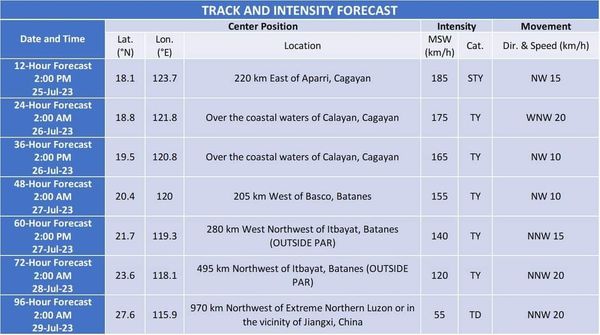
TRACK AND INTENSITY OUTLOOK
• EGAY is forecast to move northwestward in the next 12 hours before turning generally west northwestward and cross the Luzon Strait. On the track forecast, this typhoon is forecast to make landfall or pass very close to Babuyan Islands-northeastern mainland Cagayan area between late evening today and tomorrow afternoon. Slight northward or southward shift in this segment of the track (but within the forecast confidence cone) may result in a landfall or close approach over northern mainland Cagayan or Batanes.
• After passing the Babuyan Islands, EGAY will turn northwestward or north northwestward and pass over the waters south of Taiwan. It is forecast to exit the Philippine Area of Responsibility on Thursday morning. Outside the PAR region, EGAY will cross the Taiwan Strait and make landfall in the vicinity of Fujian, China on Friday morning.
• EGAY is forecast to continue intensifying and reach super typhoon category within 12 hours, although the window of intensification for this typhoon is closing. A weakening trend may begin as the typhoon passes over the Babuyan Islands due to the potential onset of eyewall replacement cycle and interaction with the rugged terrain of Northern Luzon. Further weakening is expected outside the PAR region due to increasingly unfavorable environment and the eventual landfall over the landmass of China.
Considering these developments, the public and disaster risk reduction and management offices concerned are advised to take all necessary measures to protect life and property. Persons living in areas identified to be highly or very highly susceptible to these hazards are advised to follow evacuation and other instructions from local officials. For heavy rainfall warnings, thunderstorm/rainfall advisories, and other severe weather information specific to your area, please monitor products issued by your local PAGASA Regional Services Division.
The next tropical cyclone bulletin will be issued at 8:00 AM today.
DOST-PAGASA
Link: tinyurl.com/EgayPH
Via DOST PAG-ASA
#AgriTayoSoccsksargen


